This documentation covers which geo providers one can use with Cosmic Frog, and how they can be used for geocoding and distance and time calculations.
Currently, there are 5 geo providers that can be used for geocoding locations in Cosmic Frog: MapBox, Bing, Google, PTV, and PC*Miler. MapBox is the default provider and comes free of cost with Cosmic Frog. To use any of the other 4 providers, you will need to obtain a license key from the company and add this to Cosmic Frog through your Account. The steps to do so are described in this help article “Using Alternate Geocoding Providers”.
Different geocoding providers may specialize in different geographies; refer to your provider for guidelines.
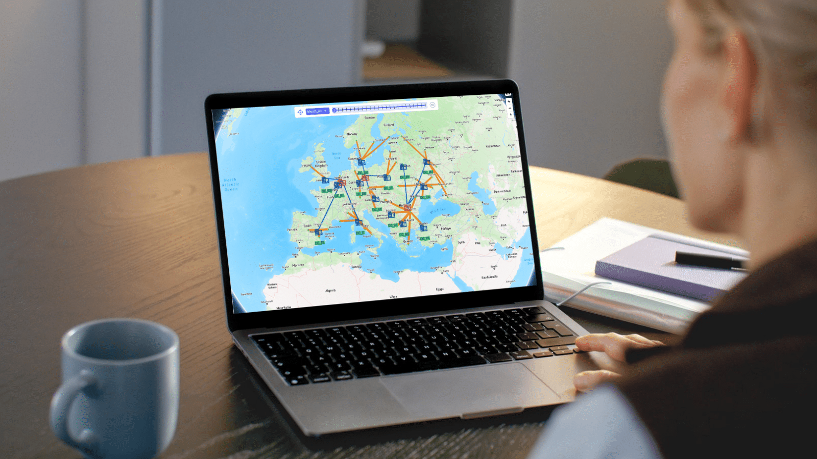
Geocoding a location (e.g. a customer, facility or supplier) means finding the latitude and longitude for it. Once a location is geocoded it can be shown on a map in the correct location which helps with visualizing the network itself and building a visual story using model inputs and outputs that are shown on maps.

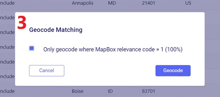
To geocode a location:
For costs and capacities to be calculated correctly, it may be needed to add transport distances and transport times to Cosmic Frog models. There are defaults that will be used if nothing is entered into the model, or users can populate these fields, either themselves or by using a Distance Lookup Utility. Here the tables where distances and times can be entered, what happens if nothing has been entered, and how users can utilize the Distance Lookup Utility will be explained.
There are multiple Cosmic Frog input tables that have input fields related to Transport Distance, and Transport Time, including Speed which can also be used to calculate transport time from a Transport Distance (time = distance / speed). These all have their own accompanying UOM (unit of measure) field. Here is an overview of the tables which contain Distance, Time and/or Speed fields:

For Optimization (Neo), this is the order of precedence that is applied when multiple tables and fields are used:
For Transportation (Hopper) models, this is the order of precedence when multiple tables and fields are being used:
To populate these input tables and their pertinent fields, user has following options:
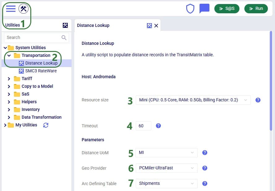
Cosmic Frog users can find multiple handy utilities in the Utilities section of Cosmic Frog - here we will cover the Distance Lookup utility. This utility looks up transportation distances and times for origin-destination pairs and populates the Transit Matrix table. As Geo Providers, Bing, PC Miler and Azure can be used if the user has a license key for these. In addition, there is a free PC Miler-UltraFast option which can look up accurate road distances within the EU and North America without needing a license key. This is also a very fast way to lookup distances. A new free provider OLRouting has been added. This provider leverages valhalla, an open source routing engine for OpenStreetMap. It has global coverage and performs the lookups very fast as well. Lastly, the Great Circle Geo Provider option calculates the straight-line distance for origin-destination pairs based on latitudes & longitudes. We will look at the configuration options of the utility using the next 2 screenshots:
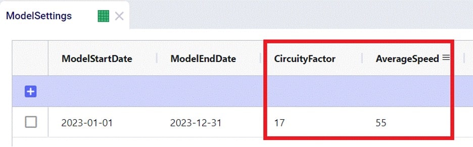
Note that when using the Great Circle geo provider for Distance calculations, only the Transport Distance field in the Transit Matrix table will be populated. The Transport Time will be calculated at run time using the Average Speed on the Model Settings table.
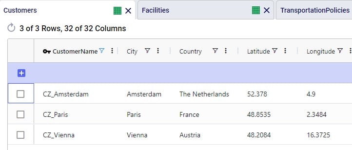
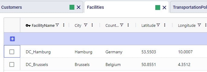
To finish up, we will walk through an example of using the Distance Lookup utility on a simple model with 3 customers (CZs) and 2 distribution centers (DCs), which are shown in the following 2 screenshots of the Customers and Facilities tables:
We can use Groups and/or Named Table Filters in the Transportation Policies table if we want to make 1 policy that represents all possible lanes from the DCs to the customers:

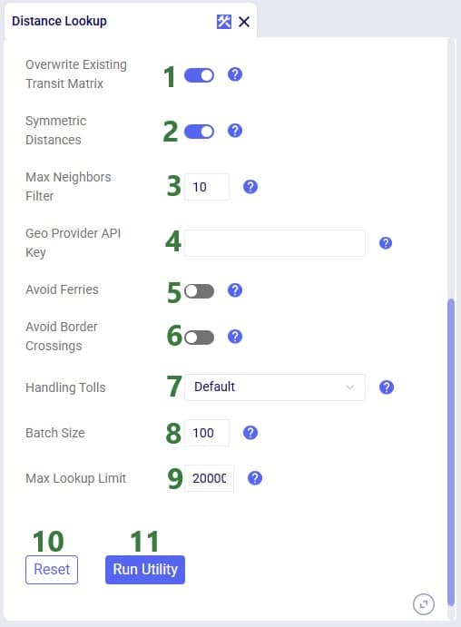
Next, we run the Distance Lookup utility with following settings:
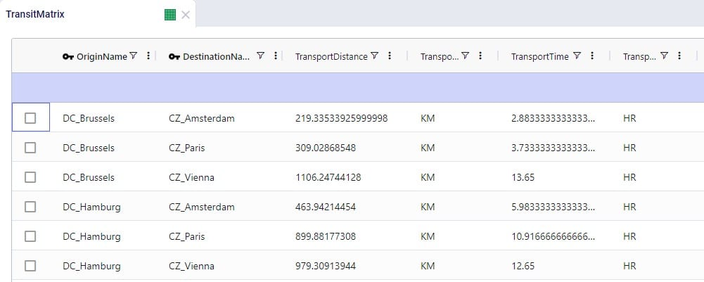
This results in the following 6 records being added to the Transit Matrix table - 1 for each possible DC-CZ origin-destination pair:

This documentation covers which geo providers one can use with Cosmic Frog, and how they can be used for geocoding and distance and time calculations.
Currently, there are 5 geo providers that can be used for geocoding locations in Cosmic Frog: MapBox, Bing, Google, PTV, and PC*Miler. MapBox is the default provider and comes free of cost with Cosmic Frog. To use any of the other 4 providers, you will need to obtain a license key from the company and add this to Cosmic Frog through your Account. The steps to do so are described in this help article “Using Alternate Geocoding Providers”.
Different geocoding providers may specialize in different geographies; refer to your provider for guidelines.
Geocoding a location (e.g. a customer, facility or supplier) means finding the latitude and longitude for it. Once a location is geocoded it can be shown on a map in the correct location which helps with visualizing the network itself and building a visual story using model inputs and outputs that are shown on maps.
To geocode a location:
For costs and capacities to be calculated correctly, it may be needed to add transport distances and transport times to Cosmic Frog models. There are defaults that will be used if nothing is entered into the model, or users can populate these fields, either themselves or by using a Distance Lookup Utility. Here the tables where distances and times can be entered, what happens if nothing has been entered, and how users can utilize the Distance Lookup Utility will be explained.
There are multiple Cosmic Frog input tables that have input fields related to Transport Distance, and Transport Time, including Speed which can also be used to calculate transport time from a Transport Distance (time = distance / speed). These all have their own accompanying UOM (unit of measure) field. Here is an overview of the tables which contain Distance, Time and/or Speed fields:
For Optimization (Neo), this is the order of precedence that is applied when multiple tables and fields are used:
For Transportation (Hopper) models, this is the order of precedence when multiple tables and fields are being used:
To populate these input tables and their pertinent fields, user has following options:
Cosmic Frog users can find multiple handy utilities in the Utilities section of Cosmic Frog - here we will cover the Distance Lookup utility. This utility looks up transportation distances and times for origin-destination pairs and populates the Transit Matrix table. As Geo Providers, Bing, PC Miler and Azure can be used if the user has a license key for these. In addition, there is a free PC Miler-UltraFast option which can look up accurate road distances within the EU and North America without needing a license key. This is also a very fast way to lookup distances. A new free provider OLRouting has been added. This provider leverages valhalla, an open source routing engine for OpenStreetMap. It has global coverage and performs the lookups very fast as well. Lastly, the Great Circle Geo Provider option calculates the straight-line distance for origin-destination pairs based on latitudes & longitudes. We will look at the configuration options of the utility using the next 2 screenshots:
Note that when using the Great Circle geo provider for Distance calculations, only the Transport Distance field in the Transit Matrix table will be populated. The Transport Time will be calculated at run time using the Average Speed on the Model Settings table.
To finish up, we will walk through an example of using the Distance Lookup utility on a simple model with 3 customers (CZs) and 2 distribution centers (DCs), which are shown in the following 2 screenshots of the Customers and Facilities tables:
We can use Groups and/or Named Table Filters in the Transportation Policies table if we want to make 1 policy that represents all possible lanes from the DCs to the customers:
Next, we run the Distance Lookup utility with following settings:
This results in the following 6 records being added to the Transit Matrix table - 1 for each possible DC-CZ origin-destination pair: